


-
 Go to download page →
-

Glendo State Park
Click here to view nowVisit our about page to find out more about our site
-
 Visit Our Facebook Page!

About - Glendo
Description:
Glendo State Park is located in the southeastern part of Wyoming. The reservoir is one of Wyoming’s top walleye fisheries and is known for other water-based recreation. With approximately 12,000 surface acres of water, it gives great opportunity to many different users at the same time. There are six boat launching areas on the park. The park has about 20 different campgrounds with over 500 campsites. Reservations can be made for most of the campsites. There are picnic shelters to help keep the afternoon sun from beating down on you, and large group shelters are available to reserve for larger gatherings.
Glendo is the home to a newly developed non-motorized trail system. It is slowly becoming a popular destination spot for some of the best mountain biking in Wyoming. There are approximately 45 miles of trails. There are four trailheads at located at Two Moon Campground, the Wetlands Area, the Dam Overlook, and at Sandy Beach Dune Shelter.
History:
Construction on Glendo Dam started in 1954 and was finished in 1958. The dam was constructed by the Bureau of Reclamation. The primary purpose of the reservoir is to store water for irrigation purposes and to help control flooding. This is the reason that the water level fluctuates at Glendo so severely each year.
Water Levels:
Glendo Reservoir was built for many different reasons. Several of these reasons being Irrigation, flood control, and power generation, just to name a few. What this means for Glendo Reservoir is that the water level fluctuates quite a bit throughout the year, on average about 55 feet in elevation. There are some key factors to understand when looking at the water levels. The main part of the reservoir and its water is what is referred to as Conservation Pool. When it is discussed how much water is in the lake, what is actually discussed is how much water is in Conservation Pool or what water has been allocated for the purposes of the reservoir, ie. irrigation, power generation, etc. As we mentioned before, this is all referenced in terms of elevation above sea level. When Glendo Reservoir is full, it is at an elevation of 4635.0. The bottom of Conservation Pool is at an elevation of 4570. That means that there is 60 feel of water in Conservation Pool. If Glendo was to be lowered to an elevation of 4570, the bottom of Conservation Pool, it would be listed at 0.0%. No, that does not mean that the lake is empty. It means that in normal operation, all allocated water has been used. There is still water in the reservoir. Below Conservation Pool is an Inactive Conservation Pool. The top of it is at 4570, same as the bottom of Conservation Pool. Inactive Conservation Pool is about 25 feet deep. At the bottom of Inactive Conservation Pool is an elevation of 4545, which is the top of what is referred to as the Dead Pool. Dead Pool is water that cannot leave Glendo. The bottom of the outlet structure is at the bottom of Inactive Conservation Pool and top of "Dead Pool." Since that water is below the outlet structure, it cannot be released. The bottom of the old river channel is at an elevation of 4508. That leaves another 37 feet of water.
This is why when talking water levels and the percentages of water in the lake, it always sounds worse than it really is. During the winter, water coming down from Gray Reef is stored in Glendo and then spring run-off adds more water to the reservoir. Due to these gains each year, Glendo usually hits its highest point in June.
 |
Site Status |
||||||||
Attention: In Effect 7/16/2026
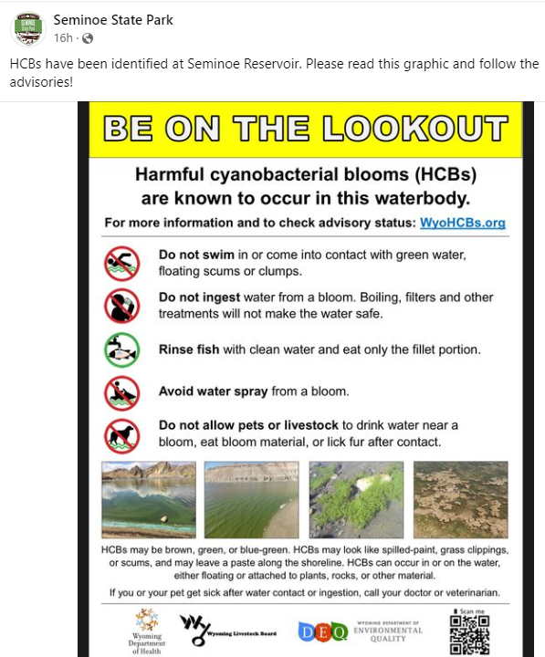
Notifications: All seasonal water is turned on. HCB Advisories in Effect ↪ Find Out More ↪ Download Flyer
Access to North Platte River below Glendo Power Plant in the Wetlands Area is currently closed to vehicular, bicycle, and foot traffic. |
|||||||||
 |
Hours |
||||||||
The park is open year-round for day use and camping. Day use permits are required from 6AM to 10PM, and camping permits are required from 10PM to 6AM. Fee booths are open Mon-Sun, from Memorial Day to Labor Day. Otherwise, fees can be paid by cash, check, or credit card at canisters and kiosks stationed at park entrances, which are available 24/7.
|


